some climbs in Switzerland and France
Here's some climbs I've done the past few weeks in Switzerland and France, having been in Basil in part for work.
As I write this I'm on a bus from Bourg d'Oisans to Grenoble, having just climbed L'Alpe d'Huez and descended via Col Serenne. What an absolutely spectacular ride that was in many ways.... I'll report on that later. The climbs I report here are relatively modest, perhaps with the exception of Le Grand Ballon, although even that wasn't to the standard of either the climb or the descent I did today.
Actually, I don't have GPS data for L'Alpe d'Huez because I took two minor wrong turns, both quickly corrected, the second and more major of which I could have avoided had I looked at the marks in the road instead of staring at the Garmin Edge 500 navigation screen, which unfortunately at the time was on a relatively zoomed-out state -- it tends to scroll between zoom levels.
Dornach - Gempen
The first climb of interest is the climb from Dornach to Gempen. That climb had a certain Old La Honda feel to it in terms of length of effort, although it's less steep. My climb rating formula gives it a ragting of 62% of Old La Honda. That 62% doesn't translate into anything in particular, not work, not time. Rather it's an attempt to combine detailed steepness and distance into a "difficulty" score. There's no such thing as a unified difficulty score, as everyone ranks climbs differently, and it's strongly dependent on what gearing one has available, but I do my best.
The profile and smoothed grade are here:


The climb as shown in tje profile gains 292 meters over 5.45 km, an average grade of 5.3%.
The climb is relatively open, with a good road surface, with enough sweeping corners to keep things interesting. It's a good local climb, definitely an attraction if you live or are staying in Basel, and good for training. The views from the top are nice, and one quickly escapes the Basel sprawl as soon as the grade begins. It's hard to nail down an obvious start and finish for the climb: I think the best places are right after the last intersection in Dornach, then right before the last intersection on the uphill side of the road in Gempen. This roughly corresponds to the limits of the profile.
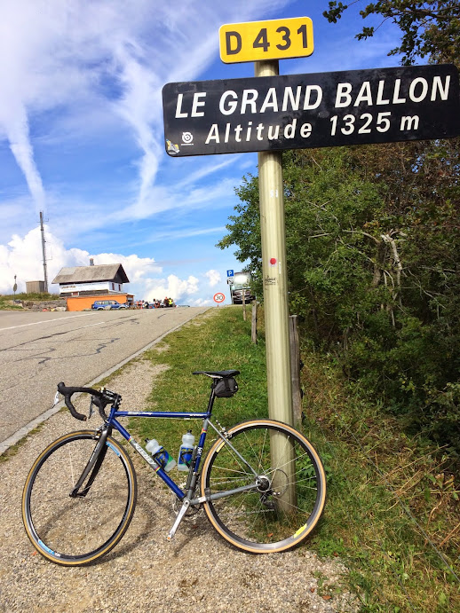
Le Grand Ballon
The next climb of significant interest I did was Le Grand Ballon (I did others, but none as challenging even as the Dornach-Gempen climb I just described). This is at the level of a category 1 Tour de France climb. The summit was crossed in the 2014 Tour de France, but from the west rather than from the south as I climbed it. There's a number of ways to reach the top, and the one I took is the one which is most accessable from Thann. I decended the same way as Le Tour, ending at the same destination, Mulhouse, although I don't think the Tour riders took the train home, as I did.
Le Grand Ballon reminds me a lot of Mount Diablo from the south, with two parts, first a more gradual climb to a junction, then from the junction to the summit at a steeper grade. Both grades are steeper than Diablo, but Diablo gets a bit of an upper hand int he comparison with it's final 17% wall, which is memorable (as Adam Yates discrovered in the 2014 Tour of California, where he attacked with 500 meters to go, only to discover the wall was more than he'd anticipated. It was painful to watch.). The surface is good and a nice touch is that after the junction the average gradient for each subsequent kilometer is marked on the kilometer signs ("milles bournes").
Here's the profile to the summit sign:

When I rode it just after the summit sign I turned left to keep climbing further. But this small addition is only a stub of a road providing access to a restaurant. Indeed it was under construction when I did it. There's a white line painted on the road, clearly indicating a KOM location, a bit after the summit sign. There's a Strava segment defined to this line. I may do another to the summit sign, since that makes a lot more sense as an endpoint for reaching the summit in the direction I did.
Hauptstrasse - Weissenstein
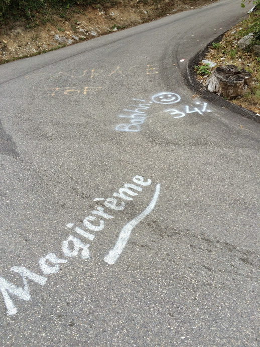
The next climb I just call "Hauptstrasse - Weissenstein" since I don't know it's proper name. The Strava segment which was there was apparently auto-generated, and was sloppy in its starting point definition. I defined another, better one, which I named along with a well-earned "oomph".
The map of the road was somewhat remarkable. The climb is switchbacked, as are many both in Europe and in the the San Francisco Bay area, but what made these switchbacks interesting was that the segments connecting them were essentially straight lines Usually roads follow contours of a hill, curving gently between switchbacks. I hadn't checked the road grade before I did the ride, the route having been generate by Strava route builder with an additional constraint point placed by me to make sure I went over the mountain. Perhaps that the road followed such straight trajectories should have been a clue as to what I had facing me.
And what I had facing me was pain. Here's the profile:

The net stats are 4.82 km, 511 meters gained, an average grade of 10.7%. As with virtually all climbs which average more than 10%, however, the average grade alone doesn't do it justice, as when roads hit that level it is a good indication the builders valued minimizing distance over smoothing out the grade.
Here's detail on the grade:

It maxes out at 17% sustained (I smooth with a smoothing function with characteristic length 50 meters).
The climb was hard. It came at the end of a decently long ride, after a number of days of reasonably hard efforts, following a period of relatively low volume. So I wasn't anywhere close to 100% going into the climb. And with each switchback, instead of providing the relief I hoped for, the road seemed to get yet steeper. Finally I partially succumbed and did a few minor traverses, which lessons the grade relative to the true road. But I didn't persist long with these, so I think the grade is fairly good.
The sustained nature of the steepness shows up in the ratings. This one, despite gaining altitude equivalent to only 1.30 Old La Hondas, rates at 2.09 Old La Hondas. My legs agreed with that assessment.
The existing Strava segments were flawed, so I was forced to define my own.
Bastille, Grenoble
Just when I thought I'd seen steep, I headed to Grenoble to ride L'Alpe d'Huez and, I thought, Chamrousse if the schedule worked out. My first day I arrived on train around noon, leaving plenty of time for a ride, but after hauling my over-filled backpack to Campanile Süd, which turned out to be a very functional if not aesthetically rewarding place to stay, I was tired and rested a bit. It got a bit late to do anything major, but I dragged myself out the door to find some food, carrying my now mostly empty backpack and wearing my running shoes and street clothes (the unzippable pants legs removed from my REI hiking pants). After getting some much-needed bread and cheese, I went to the Tourist Information office, where I saw on a map they had gondolas riding up to the Bastille, a 19th century fort perched on the steep hillside to the north of the city.
I asked if bikes were allowed on the Gondola. The office assistant said yes. I then asked if you could ride down the paths I saw on the map. No, I was told, you ride down the auto road, of which only a fragment was visible on the edge of the map. Auto road? That looked promising. I immediately gave up any thoughts of the gondola.
So I worked my way over the the auto road. This couldn't be so bad, I decided, since it took a vary indirect path to the Bastille, although the direct way was up a sheer virtual cliff, so perhaps that wasn't saying much. After turning onto Bastille road, which began by passing several old residential buildings, not yet climbing, I soom passed a painted line with words of encouragement written in French. This was obviously the start of a race.
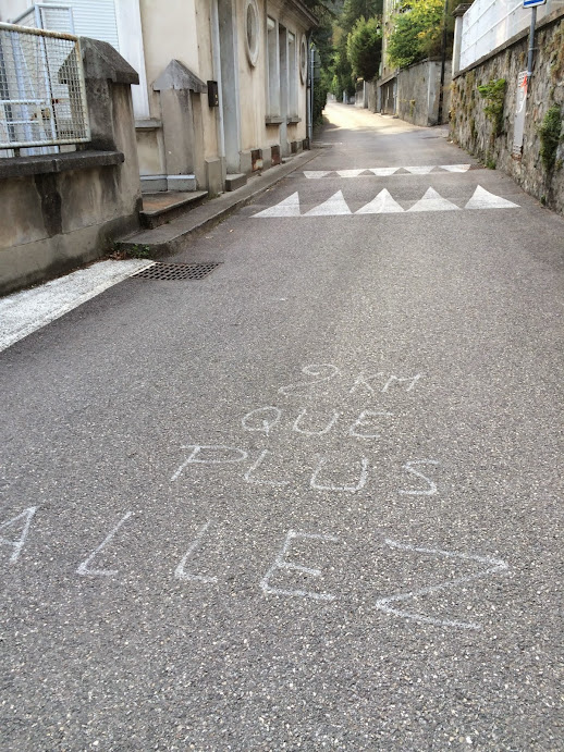
Not long after, the road pitched upwards. The paint on the road providing an ongoing dialog of encouragement, warning, even laughter at the suffering the riders were clearly experiencing. The grade was liberally annotated, with early 16% and 18% evident. I was okay with this, despite my running shoes not providing any pull on the BeBop pedals I'd installed on my Ritchey Breakaway for the trip. An early steep bit before the road leveled out? Dream on.
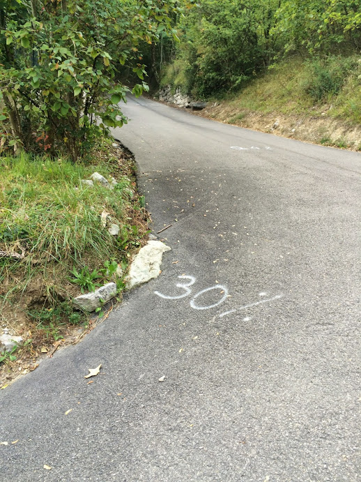
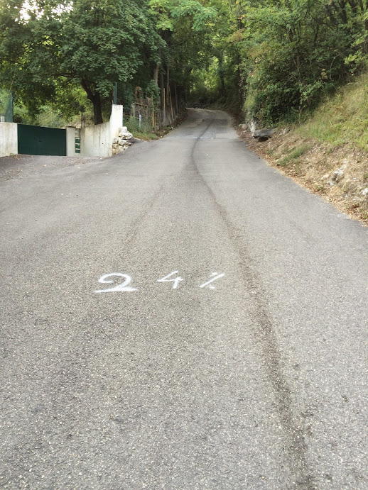
I'd been okay grinding away at the 18% early on, but my legs were beginning to fatigue. Finally I hit a corner where "30%" was written in paint. The full brunt of this could be avoided by taking the corner wide, but the two "24%"'s written on the road after it straightened out could not. 24% is my limit on the Ritchey Breakaway's 36/26 with street shoes: I used to ride it almost every day commuting home to Potrero Hill. But that was just one short San Francisco block. My legs were already severely basted from the climb so far. 24% wasn't going to happen for me, even if I could power around the corner which preceded it. The shame, the shame.... I got off and began to walk.
Several cars passed me on this walk of humilation, the drivers shouting encouragement. Finally I saw 16%. No more excuses: I got back on and was able to finish the climb, including an 18% section.
It says a lot for a climb when sections marked 12% and 13% provide palpable recovery. This thing was freakin' steep.
Here's the profile, where I manually fit straight lines to some of the interesting sections, then the numerically calculated grade, where I smooth the profile with a characteristic length of 20 meters to isolate sustained grade. I more often use 50 meters, but with grades exceeding 20% 50 meters is still a lot, so I use 20 meters here. Max with this smoothing is 26%, and I took an outside radius to avoid that 30% wall hairpin (there were steeper hairpins later).


I ran the data through my climb rating code and it came out as 1.753 Old La Hondas worth of pain. This is despite being only 27.15% the distance and with only 59.16% the climbing. However, note this works out to a grade double that of Old La Honda, and once the grade gets abover 8% on my ranking code, an exponential factor for grade kicks in.
I wanted to return and give this one a shot with cycling shoes, but unfortunately that didn't work out for me this trip, as the next day I rode to Bourg d'Oisans in the rain, the next day I climbed L'Alpe d'Huez to Lac Bassens and descended via Col Sarrene, then the following day, having taken the train back to Grenoble the evening before, I climbed Chamrousse before heading to the train station for my train back to Geneva, and from there another train to Basil. Too bad. The Bastille climb beat me.
Summary
Here's a summary of ratings for these climbs, using my climb rating formula, which is based on a detailed consideration of local sustained grades:
| climb | distance rating | vertical rating | rating |
|---|---|---|---|
| LeGrandBallon de Thann | 2.622 | 2.326 | 2.12 |
| Hauptstrasse - Weissenstein | 0.877 | 1.301 | 2.086 |
| Bastille Grenoble | 0.2715 | 0.5916 | 1.753 |
| Dornach-Gempen | 0.9966 | 0.7708 | 0.6204 |
There's three ratings for each climb: a distance rating, a vertical rating, and an overall rating. For each, Old La Honda is 1, so these are unitless ratings: more than 1 means more than Old La Honda, less than 1 means less than Old La Honda. The distance and vertical ratings are for the portion of the climb contributing to the overall rating. This may be less than the full length or full vertical of the climb if the climb begins or ends with a gradual section.
Hauptstrasse - Weissenstein from my ride to Grenchen is the highest rated due to its combination of vertical gain and sustained steepness. The Bastille climb in Grenoble was even steeper, and gets a rating of 1.753 Old La Honda's despite being only 27% the distance with 59% the vertical gain. Finally, the Dornach-Gempen climb, near Basil, is the lowest rated. It's distance is essentially the same as Old La Honda, but with only 77% the vertical gain, which in combination with the reduced grade yields an overall rating of only 62% Old La Honda.


Comments